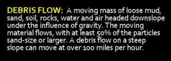
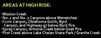
Local areas below or downstream of last year’s wildfires are at risk of flooding, mudslides, and debris flows — and area officials are closely watching rainfall levels and intensity. The soils in burned areas are not nearly so absorbent as normal, and the previous vegetation that held soil in place hasn’t completely recovered from the 2012 wildfires. When heavy rains occur in burned areas, the ash-laden runoff can cause objects that don’t normally float to do just that, and they can come ripping downstream to areas below the fire scars.

Agency officials and weather experts met yesterday to discuss the threats posed by forecasted rainstorms in the upcoming weeks. Risks of flash floods and debris flows will likely continue for the next three years, according to Greg Kuyumjian, the forest hydrologist on the Okanogan-Wenatchee National Forest who manages the agency’s Soil, Water & Air program. He says a tenth of an inch of rain in ten minutes is the “trigger point” for serious problems with flooding and debris flows.
“A hard rain or downpour for ten minutes will initiate rapid collection and monitoring of rainfall amounts,” says Kuyumjian. “The rain intensity is enough that if you’re driving, your wipers can’t keep up and you should pull over. That’s the kind of hard rain to be alert for.” He adds that the terrain in central Washington means there is always a risk of flash flooding with sustained heavy rainfall, but the fires of last summer and fall exacerbate the risk.

Amy Hendershot, Chelan County resource conservationist for the Natural Resources Conservation Service, is one of those monitoring the weather and area rain gauges. “There’s no telling when heavy rains or flooding will happen in the burn areas. You should assume that culverts in your area could become blocked, and be aware and prepared for flash floods and debris flows.”
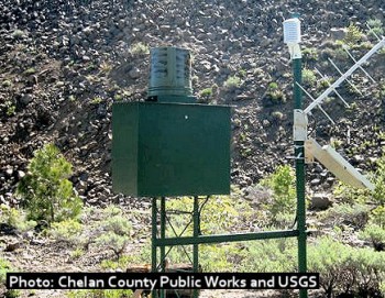
The U.S. Geological Survey (USGS) has installed rain gauges to provide an early alert system near areas burned in the 2012 fires. Chelan County Public Works Department cooperated with the county’s Natural Resource Department, the U.S. Forest Service, the USGS, Natural Resource Conservation Service (NRCS) and Cascadia Conservation District to purchase and install these gauges; the locations selected were based on historic flooding, high burn severity areas, and population centers. There are maps of the gauge locations [HERE] and [HERE], and the Chelan County Public Works page has more info on the gauges.
Hendershot recommends that residents be prepared, monitor the USGS rain gauges, and have a plan to move to higher ground in case of heavy rainfall. Items kept outside should be moved to indoor locations or secured in advance of heavy rains — boulders, trees, lawn furniture and even cars are often swept up and catapulted downstream in a heavy debris flow.
 Agency officials also recommend that residents buy and monitor a NOAA Weather Radio, which can be purchased for under $25 from numerous online sources or from local electronics stores. “Monitor the local weather forecasts in advance,” he says, “and be aware for yourself about whether you need to leave. Localized rainstorms could mean that there’s heavy rain occurring in burn scars upstream of you, even though it might not be raining hard where you’re standing. If you’re in a canyon bottom and you hear something unusual, run uphill. Get to higher ground.”
In 1981 at Tanque Verde Falls near Tucson, Arizona, a flash flood resulted from a small but intense thundershower that produced extremely rapid and concentrated runoff, and an 8-foot-high wall of water ripped down the Tanque Verde Wash through an area where over 100 people were picnicking and swimming. Because of the steep canyon walls and the sudden appearance of the flash flood, people were caught completely unaware. Eight people were swept down the wash; five went over the falls and were killed on the rocks and three others drowned. About 20 more were stranded in life-threatening positions requiring emergency rescue.
To monitor post-fire areas for flash flood risk, the USGS and Chelan County Public Works have installed ten rain gauges in Wenatchee Valley areas. The gauges function as an early-alert system, transmitting data by radar to the National Weather Service (NWS). Information from the gauges is monitored by the NWS for rainfall levels that would prompt an advisory or flash flood warning.
But Hendershot and others stress that it’s critical to be aware and be prepared. “The best thing you can do is prepare your home and family for flash floods,” she says. “You need to to educate yourself before it happens, have a plan, and make sure you have extra food, water and emergency supplies. You could be without power or water for several days, and some areas could be cut off if canyon roads are washed out by flash floods.”
Check our FLOOD WATCH page for detailed information on flood preparedness.

